Previous Chapter |
Table of Contents |
Next Chapter
Chapter 3: The Hipparchus Libraries
Introduction
The purpose of this chapter is to describe the Hipparchus Library,
how it is organized, its naming conventions and its support facilities,
including the Hipparchus Auxiliary Library.
The Hipparchus Library (hipparch.lib) provides a complete
set of ready-to-link functions for managing the geographic attributes of
your data. The Hipparchus Auxiliary Library provides the C language
source from which you may construct an auxiliary library suited to your
interface requirements (usually called hippauxl.lib).
The functions of the Hipparchus Libraries may be freely integrated
with applications developed in C++. However, to avoid the mangling
of function names, any Hipparchus C language header files included in
C++ programs should be encapsulated with the code sequence:
   extern "C" {

    ...

      }
or its equivalent.
The Hipparchus Library
All functions of the Hipparchus Library are fully re-entrant
and may be linked for multi-threaded (multi-task) execution. All are formally
documented in the Hipparchus Library Reference Manual.
h1 Data Conversion and Cell Lists
These functions provide general facilities for the conversion of latitudes,
longitudes and other angles to and from Hipparchus internal formats, for
the management of lists of cell identifiers and for the management of system
heap memory.
h2 Plane Geometry.
These functions provide for the derivation of planar items such as circles
and ellipses and for the calculation of planar productions such as the
intersection of line segments. Included are functions that provide affine
"rubber-sheet" transforms for planar data.
h3 Spherical Geometry.
These functions provide facilities for the vector algebraic calculation of
spherical surface and solid geometry productions. Examples include spherical
arc, chord, line segments and point-line proximity. Functions for simple
projective mapping and unmapping are included.
h4 Ellipsoidal Geometry.
These functions provide facilities for quadratic ellipsoidal geometric
calculations including surface distances, azimuths and conversion between
a specified ellipsoid and other domains. Functions are included that call
on the satellite orbit modeler and relate orbit positions to points on
a planetary surface.
h5 Classical Cartographic Projections.
These functions provide UTM (Gauss-Kreuger) to ellipsoid and other
ellipsoid mapping and unmapping operations.
h6 Cell Structures and Local Coordinates.
These functions provide facilities to construct, verify, maintain and
navigate Voronoi cell structures. Included in this section are functions
that manage Hipparchus scatchpad memory
h7 Terrestrial Object Manipulation and Spatial Relationships.
These functions provide facilities to construct, verify, manipulate
and relate terrestrial objects (point sets, line sets and regions).
Higher-level functions permit new objects to be derived from others as a
function of their spatial relationships. Several of the functions enable the
construction of terrestrial objects from the nadir trace or sensor swath of
satellites.
Hipparchus Auxiliary Library
All functions of the Hipparchus Auxiliary Library are re-entrant
and may be linked for multi-threaded (multi-task) execution. There are three
sections:
h8 File Access functions.
Several of these functions provide simple access to Hipparchus stream I/O
files known as point, line or region collections (PLR's). Using standard
run-time stream I/O, these provide efficient access to static geographic
vector data. Other functions in this section support dynamic memory-mapped
file access. All are formally documented in the Hipparchus Library
Reference Manual.
h9 Geographics.
These functions support the rendering of terrestrial objects and satellite
orbits as well as latitude-longitude reference grids and Voronoi cell
structures. Renderings can be displayed or plotted in any of the gnomonic,
stereographic, conic (Lambert-like), orthographic, Mercator or Miller-like
projections. Functions provide for conversion between global and
differentially-encoded coordinates and for "quick-mapping" between
differentially-encoded coordinates and the pixels of a display. In addition,
there are functions that can transform back and forth between cartographic
planar projection coordinates and discrete display or plotter pixel
coordinates.
All of the functions of this section are re-entrant, permitting linkage
for multi-threaded (multi-task) execution as well as single-thread
simultaneous generation of multiple displays and/or hard copy graphic
outputs.
These functions are designed for cross-platform GUI integration and assume
only minimal graphic primitives. The supplied source is directly compilable
for Windows 95/98/NT, but may be freely modified and re-used in other GUI's.
All are formally documented in the Hipparchus Library Reference
Manual.
h0 Utility User Interface.
These functions provide low-level user interface facilities for use with
the utility and other sample source programs provided. These are supplied in
source and although some are specific to the demo GUI environment, they may
be freely modified and re-used. All are formally documented in the
Hipparchus Library Reference Manual.
Data Structures
All data structures referenced by the Hipparchus Libraries are
defined in supplied header files. These files, referenced by your
#include statements, provide the required definitions for:
- elementary structures and unions
- coordinate and vector structures
- terrestrial object descriptive structures
- Voronoi cell index descriptive structures
- satellite orbit descriptive structures
- inter-function communications structures
In addition to their definitions in the header file hipparch.h,
many of these structures are graphically diagrammed in an HP PCL printable
file strtbls.pcl, distributed under HELP sub-directory.
The functions provided in the Hipparchus Libraries contain no
globally or locally defined static variables.
Internal Functions
All Hipparchus Library functions are available for use when
constructing your application. There are no hidden components or structures.
Many of the functions were designed primarily for internal use in
implementing the more powerful functions. So, unless you are pressing the
limits of Hipparchus, it is unlikely that you will find a need to reference
these internal functions. Nevertheless, their prototypes and specific types,
constants and structure definitions are fully described and available for
use, should the need arise.
Naming Conventions
Hipparchus Library function names are exactly six characters long
(for example, h5utmz). Full descriptive names (i.e., "long" names)
for each function are also established by #define pre-processor
statements supplied in one of the header files that are distributed with
the Hipparchus Libraries. You may invoke the functions by either
their short or long names. However, using long names adds to a program's
readability. The Hipparchus Library Reference Manual is organized
alphabetically using the long names.
Developers may choose whichever form is most comfortable. Each function
name begins with the letter h, followed by a digit denoting the
section of the library (for example, 5 for the classical cartographic
projection functions). A four-letter lower case mnemonic (for example,
utmz) completes the short name. The long names are separated from
the prefix with an underscore. The long names use both upper and lower case
letters. The long name for our example h5utmz is
h5_UtmCentralMeridian.
Hipparchus Auxiliary Library functions have long names only.
For tutorial purposes, we will use only the long names in the sample
programs.
Note: Your program's object modules will always reference the
Hipparchus Library functions by their short names. Any related
error messages issued by your compiler/linker will refer to short names.
(The Hipparchus Library Reference Manual has numerous hyperlinks to
cross-reference short names and long names).
Abbreviations
The following are abbreviations we used in constructing the long function
names. They are presented as clues to the intent of the functions:
- Bitflag
- integer word bit, used as a binary logic indicator
- Bsearch
- binary search
- Cellid
- cell number or identifier
- Cellstring
- list of cell identifiers (compressed or otherwise)
- Daynumber
- number of days passed since January 1, 1900
- Dist
- distance
- Dcos2
- two dimensional vector of direction cosines
- Dcos3
- three dimensional vector of direction cosines
- Hpsph
- "Hipparchus sphere", a near-conformal sphere corresponding to
a particular ellipsoid, synonymous with "Hipparchus Frame".
- Iso
- isometric
- LatLong
- ellipsoidal or spherical latitude and longitude
- Map
- mapping or projection from a higher-order to a lower-order surface
- UnMap
- inverse mapping or projection from a lower-order to a higher-order
surface
- Pset
- point set, terrestrial object
- Lset
- line set, terestrial object
- Rset
- ring set (region), terrestrial object
- Utm
- Universal Transverse Mercator
- Ux
- spatial union or intersection.
Function Prototypes
These are provided in the supplied header files hipparch.h and
hippengn.h. The supplied on-line HELP information details each
function prototype and provides additional notes and usage commentary
extracted from the Hipparchus Library Reference Manual.
Some functions are implemented as C/C++ language macros. These are
identifiable by their names which begin with Hx_, where x
refers to a section of the Hipparchus Library or the Hipparchus
Auxiliary Library.
Type Definitions
Standard type definitions for elementary Hipparchus constants and variables
are defined in the supplied header files hipparch.h, hippengn.h
and hippvrsn.h.
While the contents of hipparch.h and hippengn.h are version
independent, the contents of hippvrsn.h headers are associated with a
particular Hipparchus version. A separate hippvrsn.h header is supplied
for each version in the distribution. The types defined by hippvrsn.h
are few, referring mainly to the preferred word size for numbers and pointers.
Within the Hipparchus Library Reference Manual, many of the
references to these types are hyperlinked to their definitions.
Manifest and System Constants
In Hipparchus, manifest and system constants are descriptively named
from an upper-case alphabet that includes numerals and the underscore.
Manifest and system constants are defined by the supplied header file
hipparch.h.
Manifest constants are sometimes called program parameters. They are
program-related constants or codes that are given specific names for the
combined purposes of readability, scope and portability. For example, the
manifest constant MERCATOR defines a numeric code that refers to
one of the projection options.
System constants are mathematical or physical values that are considered
constant by Hipparchus and are given specific names for much the same reasons
given above. For example, the system constant ERTHRAD defines the
approximate value for the radius of the Earth.
Within the Hipparchus Library Reference Manual, many of the
references to these constants are hyperlinked to their definitions.
Computational Domains
From the forgoing description of the Hipparchus Libraries,
you will have guessed that an application that incorporates Hipparchus
technology will likely perform computations in more than one domain.
First, your external data may be expressed in the conventional geographic
coordinate domain of latitudes and longitudes (angles). Although these
angles always specify positions on an ellipsoid, they will need to be
transformed into the vector coordinate domain of that ellipsoid using one or
more of of the functions provided. Similarly, output from your application
may need to be transformed back into latitudes and longitudes.
Alternatively, your external application data may be expressed in the
planar domain of UTM or state plane coordinates and will first need to be
transformed into ellipsoid vector coordinates. If your application ultimately
feeds back into an existing "Flat-Earth" system, you may need to transform
some data back into the UTM or state plane domain, again using one or more of
the functions provided.
You must choose one of the supplied ellipsoids or else define your own.
You will normally select just one ellipsoid. (Only rarely would you work
simultaneously with data in the domain of more than one ellipsoid). If your
application works with the position of orbiting satellites, you will also be
working in the geocentric domain of near space. Knowing the instantaneous
position of a satellite in this domain, you will likely need to calculate the
elipsoidal surface coordinates of its nadir trace or sensor swath limits.
(For more on this subject, see Chapter 10: Working with Satellites).
Next, if your application deals with terrestrial objects (as most will),
your data will be need to be transformed into and manipulated in the domain
of the Hipparchus sphere. This is also known as the Hipparchus
Frame, a hypothetical sphere that is approximately conformal to an
ellipsoid at specific latitudes. Spatial relationships of objects can be more
efficiently determined in this domain. However, to properly locate any
derived objects, you will need to transform your data back into the
ellipsoidal domain. Besides the object constructors, functions are provided
to permit you to move freely between the coordinate domains of an ellipsoid
and its corresponding Hipparchus spheres.
Next, your application may need to display information in one or more
cartographic projections. These lie in planar coordinate domains that differ
according to the type of projection required (i.e., gnomonic, stereographic,
orthographic, Mercator, Lambert-like, etc.). Functions are provided to map
from the ellipsoid or the Hipparchus sphere into the desired planar domain.
For applications that may need to trace back to ground coordinates positions
designated in the domain of one of these projections, functions are provided
to "un-map" from the planar domain back to the Hipparchus sphere or ellipsoid.
Some applications may require the display and/or computation of positions
in planar projections other than those strictly defined as cartographic
projections. For example, the application may require that objects be
displayed in the same plane as an aerial photograph or satellite-sensed
image. On the other hand, the application might call for the calculation of
the ground coordinates of features indicated by a user with a mouse or pen.
To accommodate such displays and computations, Hipparchus provides functions
for the mapping and unmapping of coordinates between arbitrary planar
domains. These affine "rubber sheet" transformations provide the
computational link between these disparate planar coordinate domains.
Finally, for speed of display, Hipparchus recognizes the specific integer
pixel domain of displays and plotters. Functions are provided that can
map or unmap points between the mathematical planar domain of an arbitrary
planar projection and the corresponding pixel domain of a display or plotter.
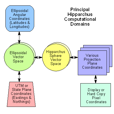
Figure 6 illustrates these various computational domains and the paths
that Hipparchus provides between them.
Computational Verification
The core elements of the Hipparchus Library have been in continuous
use since 1989. Their computational accuracy has been repeatedly challenged
and verified by concerned developers. Nevertheless, to provide developers
with a measure of self-testing capabilities, we have provided functions
that form the cornerstones of conventional computational geodesy. These
functions (h4_DirectRudoe and h4_InverseRudoe) implement
the calculation of position, distance and/or azimuths on the surface of
an ellipsoid using the traditional methods of Rudoe. Using these functions,
the developer can implement computational cross-checking of results.
Galileo for Windows 95
The demonstration program Galileo for Windows 95 implements almost
all of the functionality of the Hipparchus Libraries in the context of
a general purpose Hipparchus programmer's workbench. It is strongly
recommended that Galileo be used and its source consulted for examples
of the use of the Hippparchus Libraries.
Hipparchus Libraries Reference Manual
TheHipparchus Libraries Reference Manual provides the definitive
description of each of the functions of the Hipparchus Library and the
Hipparchus Auxiliary Library. An essential ingredient of the licensed
Hipparchus Software Development Kit (SDK), this manual provides the
programmer with the details of the Hipparchus Application Program Interface
(API).
Summary
The Hipparchus Library provides Hipparchus engine functions in
ready-to-link form. Short forms for the function names provide for improved
portability. Alternate long names are more descriptive. Type definitions,
constants, data structures and function prototypes have all been provided
in header files. The Hipparchus Auxiliary Library provides auxiliary
functions that support the sample programs.
All components of the Hipparchus Auxiliary Library are supplied
in source form and are supported by supplementary header files. \
The Hipparchus programmer's workbench program Galileo implements a
majority of the Hipparchus Library functions, in a convenient
programmer's workbench environment.
Previous Chapter |
Top of Chapter |
Next Chapter